Rising Seas, Coastal Development Endanger Indigenous Culture
Ongoing development along Rhode Island’s shoreline pushes Native people out while sea-level rise threatens to drown important cultural areas
May 17, 2021
Share
Though conversations about sea-level rise largely focus on the loss of colonial and post-colonial development, which pushed Indigenous people from the coastline, Native people in Rhode Island maintain a visceral connection to the coast that is, too, threatened by rising waters.
Lorén Spears, 54, remembered a time when sand dunes lined the beaches of South County. The coast was different when she was growing up, she said. Fewer houses bordered the water’s edge, certainly fewer on stilts. No one had to pay to go to the beach. Spears and her cousins could dig up shellfish in brackish salt ponds to make oyster stew and quahog chowder.
“We have the salt waters, marshes, estuaries, salt ponds, the bay, the ocean,” said Spears, executive director of the Tomaquag Museum in Exeter and a member of the Narragansett Indian Tribe. “All of those things have special resources that were important to our ancestors, for not only survival, but thriving. We were thriving in this ecosystem prior to European contact.”
For centuries, development has crept closer to the shoreline at the expense of Indigenous people. Prior to 17th-century colonization, the Narragansetts, who have inhabited the area along Narragansett Bay from present-day Warwick to South Kingstown for 30,000 years and were the largest of a number of tribes living in southern New England, would migrate to the coasts during the summer to harvest from the fertile land and gather resources from coastal waters.
But when English colonizers bought much of the Narragansett Indian Tribe’s land between 1657 and 1661, including what is today South Kingstown, Narragansett, and parts of North Kingstown and Exeter, they paid a paltry sum that Spears interprets as an act of stealing, and privatized “choice tracts along the water.”
Now, as the Ocean State’s marine waters creep up because of sea-level rise, with projections of up to 9.6 feet by 2100, the Coastal Resources Management Council (CRMC) in recent years has thrown itself into creating resources for resilient development along the coastline, such as its coastal hazard application worksheet and asking property owners and developers to keep sea-level rise in mind as they build.
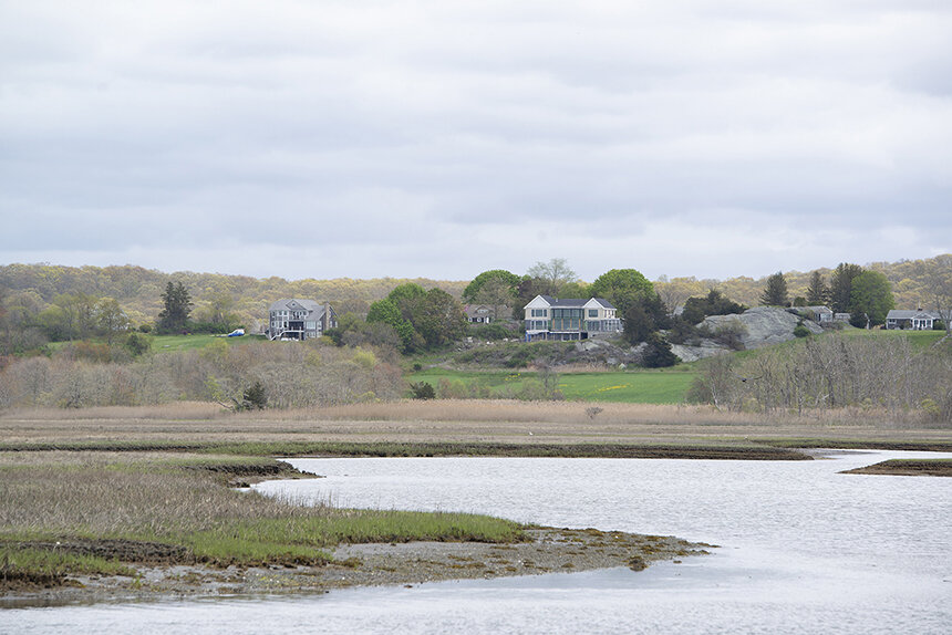
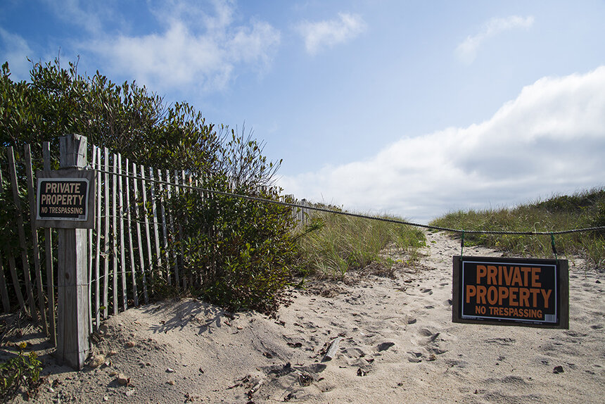
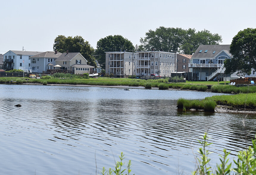
At the local level, Rhode Island’s 21 coastal municipalities are scrambling ever faster to protect public and private investments. In South Kingstown, the town fought for and won the extension of a sheet-pile seawall to protect, at least in the short term, Matunuck Beach Road, which provides access to some 240 homes. Newer coastal developments, such as The Pointe beach houses in South Kingstown, have first floors 16 feet off the ground.
But Indigenous people in the state — Narragansetts, Pocassets, Pokanokets — maintain a connection to the coast that isn’t being as well protected. Though Indigenous people are only 0.4 percent of the coastal population that would be impacted by 7 feet of sea-level rise, likely a relic of both colonization and the high cost of coastal living, many are connected to the shoreline in other ways: quahogging, hunting, cultural monuments and spiritual gatherings.
Their stories of coastal importance and what they have to lose run thousands of years deeper than the developments of the past 350 years.
Devastating impact hovers
In the Sapowet Marsh in Tiverton, low tide means bounty.
Quahogs, sometimes too deep to reach under the sandy seafloor, are nearer to the surface. Fish such as stripers and bluefish make their way into the estuaries, following bait fish like mummichogs.
On a rainy October morning at low tide, one small, brown cormorant was enjoying the buffet. After eating his fill of fish from the shallows, the cormorant propelled itself out of the water and waddled onto the rocky beach. His belly bulged, and his legs teetered beneath him.
Daryl “Black Eagle” Jamieson pointed at the cormorant and laughed.
“Look at this guy!” he said. “He’s got his belly full. He’s full of fish right now. … They’re eating anything they can find.”
For Jamieson, 60, of the Pocasset Wampanoag Tribe of the Pokanoket Nation, low tide at Sapowet Marsh signifies food for him and his family. During the past 30 years, he has used the area to hunt, fish and quahog. The location is choice for the Pocassets. Prior to colonization, Tiverton, lined by the tidal Sakonnet River, acted as the center of the Pocassets’ homeland. Even as English colonization reduced the tribe’s access to the coast — the reservation treaty deeded to the Pocassets in the early 1700s is inland — they’ve maintained a connection to the Tiverton coastline through public access areas like Sapowet and Fogland Marsh.
“I can’t tell you exactly what our people would’ve been doing, but I’m thinking they were down here doing the same thing 400 years ago, you know?” Jamieson said. “Because this is a good place for that.”
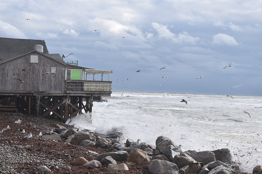
But the brackish, shallow waters of salt marshes such as Sapowet are one of the most susceptible ecosystems to sea-level rise. A 2015 multiagency report found that with 5 feet of sea-level rise, 87 percent of the state’s coastal wetlands could be lost, drowned by salt water.
“If [the sea level] keeps getting higher and higher, it’s not going to be a good marsh anymore,” said Jamieson, who has been quahogging in this area since the 1990s. “The higher the water gets, the less available food.”
Low tides or shallow water are required to harvest quahogs traditionally. During early spring and summer, Jamieson will trek out from the rocky shoreline wearing waders and carrying a rake. He’ll stop when he gets knee-deep, and scrape the seabed for quahogs hiding beneath the sand.
Quahogs live adjacent to salt marshes in sandy or muddy substrates below the tideline, sucking in organic matter such as decomposing plant material or algae that marshes send out with the tides.
As waters warm with climate change, shellfish will require shallow waters since deeper ones will struggle to circulate oxygen to a cooler bottom layer, according to Serena Moseman-Valtierra, an associate professor of coastal wetland ecology at the University of Rhode Island. In deeper waters, she said, a warmer surface layer can prevent oxygen exchange with the cool bottom, limiting quahogs’ ability to thrive.
Whether quahogging by hand can continue as sea levels rise is a much-debated question, largely dependent on whether marshes can migrate upland and if they can add land as fast as the sea washes the muddy banks away, according to Moseman-Valtierra.
But each of these may be a losing battle in Rhode Island. About 30 percent of the Narragansett Bay shoreline is already hardened by development, meaning there’s almost nowhere for the marshes to go, and since 1999 seas have risen at about three times the rate at which salt marsh is growing.
“From the perspective of anyone interested in shellfishing — will the habitat even exist going forward, or where will it exist, and what will it look like?” Moseman-Valtierra said. If marshes do migrate, “there is a question of whether the ecosystems will function in the same way. Not a lot is known about what the barriers or factors are that promote that transition, aside from the obvious: You can’t have a road or concrete structure in the way.”
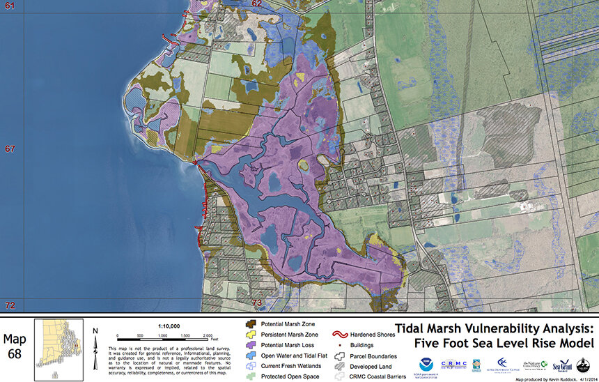
Sapowet Marsh is unusual in being somewhat prepared for rising sea levels, because of a low level of surrounding development and a gentle slope up. State agencies and nonprofits are aiding its transition, seeding a field adjacent to the beach with 9 acres of tall native grasses to create a coastal buffer zone. Wenley Ferguson, Save The Bay’s director of habitat restoration, said she expects this area to turn into salt marsh as waters rise. But CRMC maps show that at 5 feet of sea-level rise, the area of marsh lost to higher waters is larger than the marsh gained.
To lose quahogging grounds would be to lose a key piece of culture and sustenance that connects generations of Pocassets and provides food sovereignty. For centuries, the Pocassets and other Indigenous people along the Northeast coast highly valued the quahog as a source of food and a shell to turn into jewelry, called wampum. The more purple the shells, the better. While quahogs are mainly used to cook with nowadays, some Pocassets still make wampum, Jamieson said, selling them at Christmas and other holidays.
Jamieson, who is from Massachusetts, sought out Sapowet three decades ago because he knew it was Pocasset territory. He started hunting and quahogging there, using a rake instead of diving for shellfish as he did when he was a kid. Now, he’s working to teach the the next generation of Pocassets, bringing youth down to Sapowet in the spring to dig up clams.
“Last spring, we did a quahogging class down there for the youth,” Jamieson said. “What we’re trying to do is teach the children how to deal with the outdoors and how to do fishing and hunting and quahogging.”
Of course, the marsh doesn’t just provide shellfish. Jamieson hunts here for ducks, sometimes with his son. The feathers can be used to make native regalia, from headdresses to earrings, and the bird prepared into duck fricassee. And on summer days, he has come to play drums for crowds on the beach.
It is this bounty that the specter of sea-level rise threatens to rob, taking it from Jamieson and the youth he teaches, the little, brown cormorant with the full belly and every other species relying on the marsh’s silty, muddy waters.
“If the climate was to change and the waters were going to rise, it would overflow the marshes,” Jamieson said. “If the water was to change, it would create a devastating impact.”
Another layer of struggle
Pokanoket tribal historian Donald Brown, 31, grew up hearing his grandfather’s stories of forced assimilation. His grandfather’s mother — Brown’s great-grandmother — scolded her son for sharing his Pokanoket identity publicly, fearful of the consequences. His grandfather’s daughter — Brown’s mother — was labeled by the doctor as White on her birth records.
“Until very recently, it wasn’t a very popular thing to say you had Indigenous blood, to say you were Pokanoket or any other group of people,” Brown said.
After years of blatant oppression and erasure, Brown, whose Native name is Po Menuhkesu Mekenok, said society is just starting to wake up and listen to Indigenous people’s stories. Brown, along with his tribal council, hopes to tell that story in an effort to hold onto their heritage. In Brown’s case, he’s also working to pass this onto his young daughter.
This work is threatened by sea-level rise and the climate crisis, he said.
“Because of climate change, many members of our community will be struggling to survive, to pay bills, to have food, to take care of their children or themselves, in addition to trying to hold onto this identity that people are always trying to take from us,” Brown said. “It’s just another layer, another struggle.”
Pokanoket Nation historically spread through what’s now called Bristol, Warren, Barrington and East Providence. One of its cultural and spiritual centers, Metacom’s Seat on Mount Hope, sits high above sea level, but the surrounding area is rich with history sensitive to sea-level rise.
In particular, Brown is worried about nearby Myries Swamp, on land in Bristol now owned by Brown University. In 1676, the Pokanoket’s last Massasoit — Metacom, also known as Pometacom, Metacomet and by his adopted English name King Philip — was murdered in the swamp by a fellow Pokanoket who had allied with the English. Metacom’s death ended a bloody war between the English and the Pokanokets, after which most Indigenous people were moved to a reservation or enslaved.
On Aug. 12 of every year, Pokanokets go to honor Metacom in the spot where they believe he died 345 years ago.
“I remember going there as a child, being told these stories,” Brown said. “After he was killed, they cut him up into pieces, and his head was in Plymouth for decades. They made his son look at it before they sold him into slavery in the Caribbean. They told him not to come back here, or this will happen to you.”
So to Brown and his tribe, visiting the swamp and honoring their ancestor is a form of resilience and defiance in the face of years of erasure. It’s an incarnation of the Pokanoket word awootash, meaning “stand firm.” In continuing to honor and remember Metacom, Brown said, “we can never be truly erased. It’s a sign of pride in our heritage, of remembrance of who we are, and the sacrifices, the blood that was spilled.”
Rising sea levels threaten the swamp. Though Brown doesn’t believe the location he and tribal members visit annually will be completely underwater, higher waters will make the area even wetter, limiting access for elders and those with mobility challenges.
“If sea levels continue to rise within my lifetime, we will not be able to access that,” Brown said.
Out of the swamp and along a Mount Hope Bay beach, Brown described another vulnerable landmark sacred to the Pokanokets: a stone structure of three adjacent boulders, the highest about 6 feet tall, its base ankle-deep in water. Known as the Three Sisters, the monument’s history is storied.
“The Great Creator, our God, sent down these angels, three sisters, to help the people. Their names were corn, beans and squash, and they taught us how to farm,” Brown said. “Once the three sisters taught us how to farm, some of our people asked us, ‘How do we know the Great Creator sent you?’
“The Three Sisters walked into the water, just up to their knees, and they turned around, and they said goodbye. And then … the Three Sisters turned to stone. That’s right on the coast.”
When he was a child, Brown remembers being able to walk to the Three Sisters without getting his feet wet. Now, it’s always surrounded by about 6 inches of water. Even though it would take 6 feet of sea-level rise to cover the boulders, which isn’t expected until about 2080 based on National Oceanic and Atmospheric Administration projections, a rise of just a few feet could mean that the stones are farther from the shore and less visible to future generations.
Brown worries the Three Sisters are likely to disappear during his daughter’s lifetime. For him, that’s one of the biggest challenges of his tribe’s culture and history: how to pass these monuments on, when their markers are more fleeting than they appear. He walked her down to the three rocks last summer, when she was an infant, to have her touch them.
“She won’t remember yet,” Brown said. “[It] may very well only be stories to her, and then her descendants as well. Because they won’t be able to actually access it.
“One day, the water’s going to go over those rocks, and then by and by, generations go around, it’s just going to become another legend. Someone will say — one of my descendants or another Pokanoket — fifty or sixty years from now, ‘Somewhere in that bay are the Three Sisters.’ And more of our culture, more of our history, is gone. You can’t always build right on the water.”
An abundance of loss
Loss, especially environmental loss, isn’t new to Jamieson, Brown and Spears. In the ’90s, Jamieson noted that the ducks he hunted flew so thick through the Sapowet Marsh that it looked like a hornets’ nest. Spears is increasingly frustrated with construction atop swamp and coastal ecosystems, development that makes flooding more extreme and diminishes available resources such as cranberries and marsh grasses.
But with centuries of such upheaval under their belt, Spears said Indigenous people in Rhode Island are some of the most adept at climate adaptation — and others would do well to listen.
“That’s something Native people know how to do. We know how to adapt,” she said.
She recalled a story about an ancestor who created a quahog farm beneath the waves so he wouldn’t have to search throughout the ocean to find the shellfish. He would move small quahogs he found into one spot, so that in the future, he could return to find what was essentially a colony of bigger quahogs readier to harvest. This, she said, showed how resilient the Narragansetts are when it comes to living with water, whether it be creating clam colonies or moving inland to avoid rising seas.
About 9,000 to 11,000 years ago, sea levels off Rhode Island’s coast were so low that vegetated plains stretched out to what is now Narragansett Bay, Greenwich Bay and the waters around Block Island. Archaeological evidence has placed Narragansett Indian Tribe members at some of these sites, which are now underwater. As glaciers melted, sea levels rose to encircle Block Island and fill Narragansett Bay, forcing the Narragansett people to move back from the shore.
“What did our people do? We didn’t just wait for it to wash us out to sea,” Spears said. “You moved inland.”
This clashes with the development Spears sees going on along the shore today. New houses are still being built, albeit more often on stilts. Development is still being proposed next to the ocean. Much of this new development is on top of infill that buried coastal wetlands.
Spears believes today’s decision-makers need to take a lesson from the Narragansetts of thousands of years ago and consider retreat. According to URI’s Moseman-Valtierra, it’s land-use decisions like this that will determine whether wetlands can migrate as sea levels rise.
“Is there urban removal that needs to happen?” Spears said. “If we’re talking about coastal towns that have a lot of asphalt right near the ocean, is there going to be a town that we need to remove those roadways, and other urban structures, so that those toxins from the tar are not just left in the ocean?”
For Spears, the changes she has witnessed along the coast over the years, from increased development to being required to pay to go to the beach, are present-day iterations of colonization. Letting go of colonial and post-colonial development as something to save at all costs, and instead focusing on retreat, would be a step in the right direction — for both Spears’ Narragansett roots and Rhode Island’s coastline.
“You can’t always build right on the water. That’s a Eurocentric approach to development rather than balanced lifeways, that we have this affluence that you have to be right on the beach,” Spears said. “Well, maybe you shouldn’t be. Maybe McMansions that are along the waterways don’t belong there, and maybe we need to move them away and restore that land to its rightful natural state in order for the waters to have the opportunity to move about.”
It is time for urban removal from the shoreline