Nuisance Flooding More Than a Hassle for Touristy Watch Hill
May 3, 2021
Share
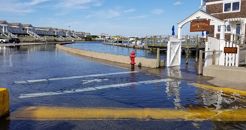
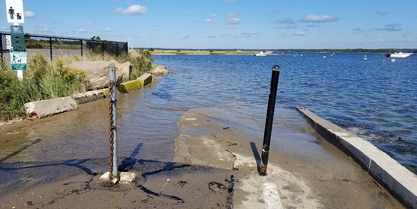
WESTERLY, R.I. — The Napatree Point access route and Larkin Square in Watch Hill are on the verge of inundation. The water level is mere inches below the adjacent concrete on a calm day. During high and king tides, waves easily breech the seawall near the Watch Hill Yacht Club, submerging parts of the parking lot and blocking the access point to a popular conservation area.
This continued nuisance flooding has prompted officials in this coastal village to monitor rising waters and gather evidence and community support before embarking on ambitious stopgap measures to mitigate further damage and buy time.
“I’ve been here 12 years, and except for storm events, flooding was not an issue. Then three years ago, I started noticing a tide line where it didn’t usually reach. In the past two years, we are seeing increasingly more water,” said Janice Sassi, the Watch Hill Conservancy’s manager of the Napatree Point Conservation Area. “It’s at the point where I have to consider tides when I’m planning an event or work, because the entrance to Napatree Point is not accessible during high tides.”
Using a slate of tools, including geographic information system (GIS) mapping, time-lapse photography, a U.S. Geological Survey tide gauge in Watch Hill Harbor, and the Coastal Resources Management Council’s STORMTOOLS inundation model, the Watch Hill Conservancy (WHC) learned that there is an alarming increase in nuisance high tides.
In 2019 alone, Napatree Point access was flooded and became impassable on 121 days, according to Peter August, chair of the WHC science advisors and retired professor of ecology at the University of Rhode Island.
Coupled with about 11 inches of sea-level rise since the 1930s and increased storm frequency and intensity, Watch Hill’s local businesses are vulnerable to flooding. When sea level rises 2 feet, August projects that the Larkin Square parking lot, which butts up against Watch Hill Harbor, also called Watch Hill Cove, would be flooded at every high tide; at 5 feet, much of Bay Street would be underwater at high tide; and after a Category 3 hurricane, all they could do is clean up.
And since the roadway to Napatree Point is only 1.15 feet above high water, August said the entrance is now submerged at extreme tides.
“On tides one foot above our typical high tide now, you have to wade,” he said. “A kayak would be a better way to access Napatree.”
Sea level isn’t the same every single day, according to Bryan Oakley, a WHC science advisor, Westerly resident, and professor of environmental geoscience at Eastern Connecticut State University. Spring tides are a foot or two more above an average high tide, and king tides are even greater, which exacerbates flooding and potential damage to businesses.
“So, once we get to a threshold, we’ll start to see the flood that used to happen once every few weeks, will happen multiple times in a few weeks, and then 10 times in a few weeks. It’s creeping,” he said. “Eventually, we’ll get to a point that we have to take action on a larger scale. Is that when roads flood once a month or 10 times a month? There is no set answer, it’s community by community.”
Hoping to prevent catastrophe until they can devise a more permanent solution, the Watch Hill Fire District (WHFD) and the WHC were awarded a $250,000 grant from the Rhode Island Department of Environmental Management’s Climate Resilience Fund to elevate and fortify the Napatree Point access route. The plan is to raise the elevation of the entrance using all-natural materials, including stone and sand, that will create a buffer against heavy wave action.
Eastern Connecticut State University and URI students studying engineering, landscape architecture, and environmental economics were enlisted to envision Watch Hill’s future and provide possible long-term solutions. They spoke with environmental experts to discuss the reality of the flooding and the science behind sea-level rise. They heard from concerned local residents and business owners.
“After a nor’easter in March 2018, we saw two feet of storm surge in Watch Hill, and the WHC had a dramatic preview of what that sea-level rise would look like in this area,” WHC executive director Jocelyn Lahey said. “So, we started our Planning for a Resilient Future initiative to address current and future sea-level rise and storm-surge impacts.”
Thinking differently about how the shore is developed is critical, according to Save The Bay’s South County coastkeeper Dave Prescott.
“But that doesn’t mean we have to change the way we live,” he said. “The conversation around the shore is using words people don’t like, like retreat, which is loss. But none of it has to be doom and gloom. There are opportunities here.”
The Watch Hill seawall is the first target, as it’s dated and crumbling in places. Because the ocean places high hydraulic pressure on it, seawater will actually seep through it, noted August and former WHFD parks commissioner Grant Simmons. They are evaluating methods to eliminate seepage or raise Fort Road so it won’t be compromised during high tides.
“We have a low point in the seawall, by the yacht club entrance, and if we raised that, it would mitigate water surging into the parking lot,” Simmons said. “And if we raised the roadbed enough, we could mitigate the issues of nuisance high tide. But how high is high enough? We still have to figure that out.”
Elevating and sealing the cracked parking lot should buy the area 10-15 years of public access and would minimize impact to shopkeepers in Larkin Square, according to August.
“The lack of access to Napatree Point and lost parking are big issues. But the invisible issue is that all these businesses and condos are on septic systems. And those will fail as the groundwater elevation gets higher and higher,” August said. “We have a little bit of time to really understand what the issues are for a long-term scenario. And the students did a great job of visualizing what can be done with out-of-the box solutions. But it would be very different from the Bay Street we have now.”
Multiple businesses already have elevated to protect themselves from nuisance flooding and sea-level rise, including the Watch Hill Yacht Club and the Lanphear Livery, where the WHC office is located. The Livery was rehabilitated, restored, and elevated 2 feet in 2016. The Watch Hill Yacht Club was also raised about 2 feet.
“I have noticed that the tides have been coming further into the parking lots in Watch Hill on a day-to-day basis. A couple of months ago we had exceptionally high tides, and I had never seen water at that level,” Lahey said. “The basis of the reconstruction of the Livery was that we know that a major storm is overdue, and the building must be able to survive the ensuing inundation. It’s a great model for historic preservation in that you can preserve the historic character of a building yet mitigate anticipated sea-level rise and storm-surge impacts.”
Georgia Jones has seen water engulf parking spots and creep up to the sidewalk in front of her family’s century-old business, the Olympia Tea Room restaurant on Bay Street. Lost parking means lost business for the whole community, she said, so they’ll have to do more than sandbag the front door to protect their livelihoods.
“Our plan for the future will be to lift the building up, but meeting the extensive criteria will be difficult. It’s our only option,” Jones said. “We are staring at the ocean, and the front door is approximately seven feet above mean sea level, so we can’t put this on the back burner.”
Short-term fixes, such as reinforcing and rebuilding the seawall or moving businesses to the second floor and losing the residential housing, will buy time, August said, but he admitted longer-term solutions are more challenging. Moving the businesses to downtown Westerly, for instance, would change the uniqueness and character of Watch Hill and create competition downtown. There are no easy answers.
“How effective will a seawall be when we have three to five feet of sea-level rise? Does it have the physical ability to hold back that much water, or do we fortify Bay Street another way? We have to protect this area from being washed away,” he said. “Retreat isn’t just a sea-level rise issue, it’s a storm issue. If a major hurricane comes through, there will be significant property damage. And that’s when retreat becomes a serious option for residents.”
ecoRI News staffer Frank Carini contributed to this report.


It is time to get really serious about retreating from the coast line. It is time to get really serious about ending the use of fossil fuels. It is time to get really serious about ending deforestation, here in RI and elsewhere. Do not buy property along the coast, beyond sea level rise, the storms are getting stronger;. Free buses on RIPTA is an idea who’s time has come.
We passed Act On Climate 2021 this year. Now lets really get moving on all of the things we need to do to get to zero emissions and restored ecosystems.