How to Move a Marsh: Work Continues to Save Sapowet Marsh
December 12, 2021
Share
TIVERTON, R.I. — The grasses are dying. Clusters of broken, denuded stems stand in shallow pools of brackish water, making a patchwork of the low-lying marshlands.
The slow balding is invisible from the blacktop of Seapowet Avenue, hidden behind a thick curtain of phragmites. But standing boot-deep in the peat, surrounded by the sulfuric scent of decomposition, the bare ground is clear evidence of the steady saltwater creep happening in marshes across Rhode Island.
Spartina alterniflora, or smooth cordgrass, is notoriously salt-tolerant and a common feature in saltwater marsh environments.
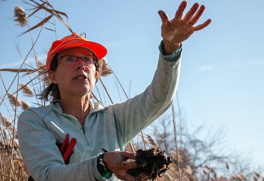
“They can grow along the edge of the cove and get flooded twice a day, but they can’t grow in standing water,” said Wenley Ferguson, shovel in hand. All around, the sunlight glints off pools of standing water, unable to drain and slowly growing with each high tide.
The average sea level in Rhode Island has increased by about a foot since 1929. Storm surges and king tides have pushed further and further inland. Normally, the marsh would respond to the rising high-water line by matching the migration inland.
But with the sea on one side and a dense web of roads, development, cultivated fields, and invasive species on the other — and accelerated sea-level rise on its way — Sapowet Marsh has nowhere to move.
But Ferguson, the director of habitat restoration at Save The Bay, is working to save the marsh from that saltwater grave.
Ferguson has been working with the Rhode Island Department of Environmental Management (DEM) at the Sapowet Marsh Wildlife Management Area, a 260-acre state property, for more than five years now.
The coastal edge of Sapowet has seen more than 90 feet of shoreline erosion in the past 75 years. Under Ferguson’s watch, Sapowet has become home to the largest marsh migration facilitation project in the state — a small counter to the forces at play.
“When I say facilitate marsh migration,” she said, “it’s kind of like prepping the land for the marsh to migrate.”
Back in 2017 and 2018, Save The Bay and DEM, along with the Tiverton Conservation Commission, restored 9 acres of coastal grassland and reestablished beachside dunes on the northern side of the marsh to slow erosion.
Now the work has moved to the west and southeast sides of the marsh — and the strategy has changed to match.
Along the western front
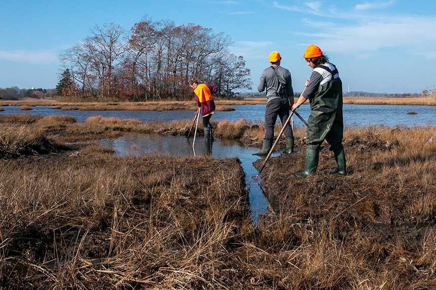
The cordgrass roots are taut, but they cut easy. Just one stomp and the shovel sinks through the muck, water pooling up and over the toes of Ferguson’s black rubber boots.
It was a warm and clear November day — too warm, according to Ferguson. She packed for a cool fall day and wore a blue-flowered fleece, but 60 degrees means she’ll be sweating by midday.
Earlier in the week, Ferguson — along with a handful of DEM employees and volunteers — used shovels and a small excavator to dig a weaving network of runnels through the marsh. These shallow creeks will give the pooling water a route out to Narragansett Bay, allowing the area to slowly drain.
If the root zone of the marsh plants is able to dry even slightly, they will grow “healthy and happy,” Ferguson said. Healthy plants build up a stronger root base, and a stronger root base makes a coastline more resilient to erosion and sea-level rise.
But “we don’t want to drain it too fast,” she said. It has been three days since they dug the first runnels and the water level has dropped only slightly, exposing a few inches of bare mud — exactly as planned.
The standing water is thick with unconsolidated sediments and topped by a bacterial mat. If the water rushes out all at once, this sediment will pour into the bay. It’s better to dig in phases and let it settle out in the marsh, maintaining as much high ground as possible.
They are back on this day to adjust the runnels, excavating the areas where the muck has naturally dammed up. Lucianna Faraone Coccia, a Save The Bay volunteer and an environmental science master’s student at the University of Rhode Island, shovels out a cluster of grass roots.
“If that’s in there, it could plug up this whole runnel,” said Faraone Coccia, glancing down to point out a fiddler crab fumbling its way along the channel with its unbalanced claws.
With each shovel-full, the flow of water grows incrementally stronger and piles of dislodged peat beside the runnels grow larger.
“That’s technically considered fill,” said Ferguson, tossing another glob of peat toward the pile beside her. “We actually leave the peat on the marsh and we create these small little islands.”
These islands are about a chunk of peat thick —some 6-12 inches, not too high, Ferguson said — but that small elevation rise “is like a mountain in a marsh.”
Ferguson fought to keep the peat in the marsh, acquiring additional permits from the Coastal Resources Management Council, DEM’s Office of Water Resources, and the Army Corps of Engineers. This microtopography is essential for a healthy marsh surface, she said.
“These areas will just be a little higher, and they might recolonize,” Ferguson said. “And when I say might — they do recolonize.”
Within one season, the islands will host new sprouts of cordgrass, or they’ll prove high and dry enough to support clusters of high marsh grasses. The clusters of high grass will make ideal nesting habitat for the saltmarsh sparrow.
As healthy salt marsh has waned, so has the population of the saltmarsh sparrow — a bird that makes its nest out of a cup of dense high marsh grasses. The nests are built to withstand the highest moon tides, created with a dome so “the eggs float, but they don’t float out of the nest,” Ferguson said. But the area here is flooding too frequently, contributing to nest failure.
“That’s why these little islands that we’re creating are really valuable habitat,” Ferguson said.
Old ways and leftover lines
The state of marshes today are the result of centuries of human development and marshland intervention. According to Ferguson, nearly every marsh in the country holds some sort of historical impact. They are in no way pristine.
“So many of them were manipulated in this area for agricultural activity. And then in more recent years, we put roads along them,” Ferguson said. “We culverted them. We created duck habitat and impounded them. We filled them.”
From the 1700s to the 1900s, about 50 percent of marshes in the region were filled, according to Ferguson. Agricultural embankments have manipulated the marsh surface too, dating back to about the 1600s when people started haying in these areas.
“The fresher the marsh grasses, the fresher the water table, the greater the value of the hay,” she said.
When she digs these runnels, Ferguson is always scouting for clues to what shaped the marsh seen today. A shovel full of root matter means a stagnant pool was once a field. Water pooling along straight lines could be a sign of an old embankment. Long straight trenches are likely remnants of old mosquito ditches — once made to reduce mosquito breeding grounds but now speeding marshland erosion.
The marsh’s tired past — coupled with its location in an old river valley whose steep sides make marsh migration difficult — spell out a challenging future.
“That’s why what we’re doing today is trying to restore some health of the marsh … under current conditions,” Ferguson said, “but always looking at where the marsh wants to go.”
The eastern blockade
“Be careful of your eyes walking through this,” said John Veale, habitat biologist with DEM’s Division of Fish and Wildlife, as he pushed away the sharp corners of dozens of broken phragmites. “It can be a little bit dangerous.”
In the past century, invasive phragmites species — few native phragmites remain — have taken advantage of weakened saltwater marsh ecosystems to rampage through North American. The eastern edge of Sapowet Marsh, tucked below Old Main Road and several DEM-owned cornfields, is no different.
In many ways, phragmites are the perfect storm. Their feathery seed heads catch the light beautifully, but they also catch the wind and spread like wildfire. Once the seeds take hold, the reeds grow so densely they all but eliminate animal habitat and outcompete native grasses.
On Sapowet Marsh, it serves as an impenetrable blockade to marsh migration. Only a few grapevines are brave enough to reach their tendrils into the thicket. For the marsh to move away from the encroaching seawater, the phragmites need to loosen their hold. But that’s a notoriously difficult task.
“There’s no way we could do it with a shovel,” Ferguson said. “I mean, it’s just so hard. It’s one thing a little patch of phragmites. It’s another thing when it’s head-high.”
Mowing and burning do little to control phragmites, and pulling them out by the roots quickly proves costly. But like the smooth cordgrass, it is vulnerable to salt water. If Ferguson can drain the pooling fresh water and facilitate tidal flow up into the phragmites, they might dissipate — and the native grasses might have a chance at survival.
“We’re not going to get rid of the phragmites, but we can reduce the height and vigor of the phrag by facilitating that freshwater drainage,” she said.
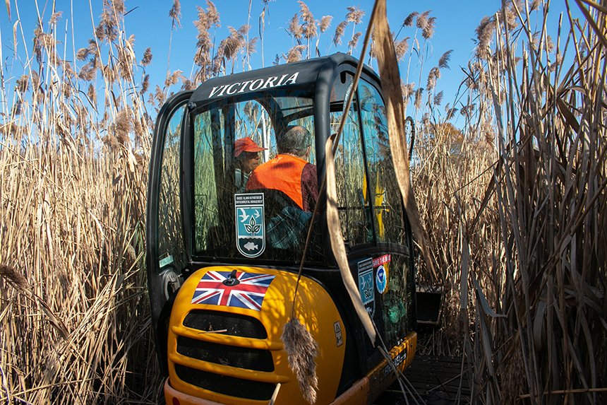
Ferguson is in the early stages of battle on this front, just figuring out the plan. The phragmites grow 10-12 feet high in places, obscuring the lay of the land.
“There’s enough water,” Ferguson said. “It’s coming from someplace. I just can’t figure out the drainage cause it’s too thick.”
She has called in the help of an excavator. Within a few hours, the machine has established a clearing in the reeds and deepened part of a natural creek. Once some of the standing fresh water drains it will be easier to gauge the direction of the water flow.
Ferguson and her team intend to elongate the creek and the old agricultural ditches — putting past mistakes to better use — but for now the plan is still in development. Better to move slowly than be patching more mistakes up in a hundred years.
“The deterioration along the marsh edge is pretty remarkable, in a terrifying sort of way in my mind,” said Ferguson, pausing to point out a flock of buffleheads skimming into the water. “So that’s why we want to be really cautious on not making new openings for that erosion to expand upon.”
Editor’s note: The above video was shot by BT Hathaway, founder of New Bedford, Mass.-based SKYCAM Films.


It might be a good idea to explain how the runnels being dug differ in form and effect from the old mosquito ditches.
Doug, that is a valuable comment. The former mosquito ditches were typically deeper and wider, often 2-3-feet deep below the marsh surface, and wide, sometimes reaching 5-foot width, In contrast, the runnels are typically no deeper than a foot and no greater than a foot wide.
I haven’t paddled Sapowet for many years but as the drone video shows, the losses are stunning. Any chance the bridge at Sapowet is restricting the flow? The stone abutments appear to restrict passage. The current sure rips through there with the tides.