Southern N.E.’s Coastal Landscape is Shrinking
December 6, 2014
Share
WICKFORD, R.I. — At normal high tide, the Biggest Little has always become the Biggest Littler. Now, during a moon tide — the highest of high tides — parts of Rhode Island, such as the Brown Street municipal parking lot in this historic village, routinely flood. Rising seas and decades of poor land-use management are conspiring to reshape Rhode Island and, unless you have gills, the new state map will have much less appeal.
In fact, rising seas present myriad challenges for southern New England, such as saltwater intrusion, accelerating erosion and loss of critical tidal marshes. The Ocean State’s well-being is intimately tied to its 420 miles of coastline and the flow of the tides.
“We’ve made enormous investment in and on our coasts,” said Sen. Sheldon Whitehouse, D-R.I. “Resiliency planning is vital to our state’s future. Climate change has baked in a lot of the damage already. There’s going to be a little bit less of the Ocean State in the years ahead.”
The senator noted that the Newport tide gauge shows a 10-inch sea-level rise since the 1930s, and the mean water temperature of Narragansett Bay has increased 4 degrees.
Whitehouse’s concern about climate-change impacts kicked off an Oct. 2 “resiliency walk” along Wickford Harbor. The 2-mile walk began and ended in the Brown Street municipal parking lot, which the tour’s guide, Teresa Crean, noted would be flooded had the event been scheduled during a moon tide.
“We’re standing in a key spot,” said the community planner and coastal management extension specialist with the Coastal Resources Center and Rhode Island Sea Grant. “During moon tides, this parking lot is closed because of tidal inundation. Ducks would be floating here now.”
Instead, the large impervious surface was full of cars, plus some 35 people concerned about the sea creeping closer to homes, businesses and infrastructure. Crean told those gathered that the day’s tide was actually a foot higher than had been predicted.
Change is here, and more is coming, but is southern New England prepared to deal effectively with shifting sands, eroding coastlines, disappearing coastal wetlands and crumbling infrastructure? The evidence suggests this oceanfront region isn’t, despite an abundance of dust-gathering studies, the creation of task forces and commissions, empty proclamations such as declaring October “Salt Marsh Month” and bureaucratic bragging.
The ongoing transformation of southern New England’s coast is unstoppable. But when it comes to addressing the rising tides, reality is routinely ignored.
Elected officials, appointed officials, municipal planners, business owners, voters and beachgoers should all be demanding, “What are we going to do?” But far to few are even asking the question, and many seem content to let future generations figure it out.
During this past election cycle, for example, the issue of climate change in general and coastal erosion in particular were seldom discussed seriously in any southern New England political race or by any one campaign — a show of stunning ignorance in a region renowned for its beaches, coastal attractions, and dense shoreline development, both commercial and residential.
Smart, informed decisions are the best way to deal with the complex problem that is climate-change impacts. Unfortunately, best decisions are more difficult to make. The pushback against them is well funded and loud.
Instead, a largely dysfunctional political system creates a patchwork of regulations that are enforced on a whim, and recommends best practices that are entirely voluntary. Elected leaders avoid examining difficult questions, such as: When does it become more cost effective to relocate vulnerable properties or retreat from the coast? They continue to hesitate when it comes to making changes that actually matter.
Hard decisions
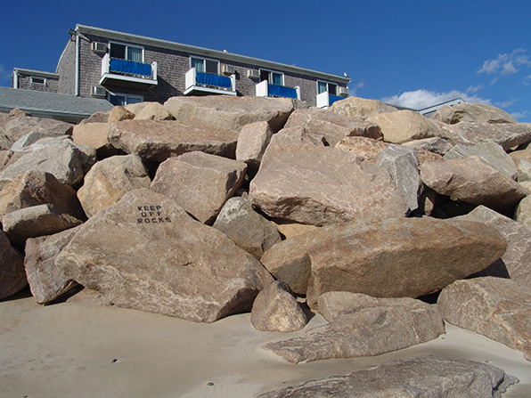
Despite seawall construction, beach renourishment and other Band-Aid measures, Rhode Island’s shoreline has lost nearly 300 feet of beach in the past 50 years. Nearly half of the Ocean State’s coastline is unsuitable for hard-structure protections because of severe waves, flooding and erosion, according to the state’s Coastal Resource Management Council (CRMC).
Seawalls and other hard structures also exacerbate erosion at adjacent beaches and neighboring properties. Seawalls are vertical structures often made of concrete or timber, and are driven into the ground to deflect oncoming waves. But this deflected force has to go somewhere. It typically accelerates erosion in front of the wall and/or to the sides. Eventually, erosion occurs behind the wall and the structure is rendered useless.
CRMC prohibits hard structures along Type 1 beaches, such as the exposed southern shoreline in communities from Point Judith to Westerly. Matunuck, Misquamicut and South Kingstown Town Beach, for instance, have lost some 400 feet of beach combined in the past four decades.
In June, however, the state agency voted 5-4 to uphold a 2012 decision, in which it approved a 200-foot-long steel and concrete wall to save a stretch of Matunuck Beach Road, which serves as the only road to many summer homes and waterfront businesses in South Kingstown. Most of the wall will be buried, and it will be capped with a sidewalk and a 3-foot cement wall.
The council’s majority said it had adequately considered the seawall’s environmental impacts. One of the CRMC board members who upheld the earlier ruling noted, “It’s the least-imperfect option of all the imperfect options we have.”
Ocean Mist owner Kevin Finnegan had appealed the original ruling, claiming the structure will damage his nearby property. His popular nightclub and eatery sits over Matunuck Beach, which has eroded significantly in recent decades. His building rests on wooden columns, and the back of his business abuts the road, leaving Finnegan with no room to retreat inland.
After that three-hour hearing in late June, the agency reminded him that he and other shoreline property owners in the area will receive notices that they must remove a wooden stockade-style fence they had installed without authorization behind their buildings.
At some point very soon, highly vulnerable areas along the southern New England coast will need to consider managed retreats, which allow the shoreline to advance inward unimpeded. As the shore erodes, buildings and other infrastructure would be either demolished or relocated inland.
In many situations attempting to stop erosion through structural or non-structural solutions is a losing battle, according to the National Oceanic and Atmospheric Administration (NOAA). The federal agency says shoreline protection efforts and their ongoing maintenance are costly and ultimately ineffective at preventing further erosion.
A managed-retreat approach is typically less expensive than structural stabilization projects that are often only temporary solutions, especially in high-erosion areas, according to NOAA. This approach also maintains natural shoreline dynamics and enables shoreline habitats to migrate inland as the shoreline erodes to prevent loss of wetlands and other intertidal areas.
Of course, as NOAA correctly notes, a managed-retreat response to sea-level rise and coastal erosion can be politically difficult to implement, especially where significant development has already occurred. Such a move may also cause depreciation of shorefront property values.
Rising waters
By 2050, anticipated sea-level rise will vary greatly along the 95,000 miles of U.S. coastline, but the trend is that the tide is getting higher and storm surges more powerful. Southern New England can already attest to both.
On Thanksgiving Day six years ago, a home on Plum Island fell into the ocean. A storm about 200 miles off the coast of Massachusetts generated intense, unforgiving waves that pounded the small barrier island. Five years later, eight more Plum Island houses were washed into the sea. Early this year, a section of rock wall designed to protect another island home didn’t. Powerful waves smashed the home’s deck into pieces.
The Army Corps of Engineers has issued a report noting that erosion along the Plum Island shoreline is claiming an average of 13 feet of sand annually. The report warns that another 26 homes will likely be lost by 2019.
Despite this knowledge and the fact the federal government opted out of funding any improvement and protection of Plum Island beaches three decades ago, the owners of the nine homes lost since 2008 were allowed to rebuild.
During a recent workshop entitled “Rising to the Challenge: Preparing for Sea Level Rise in Southern New England” the moderator asked a room largely full of planners and municipal/state officials if their cities or towns have plans to deal with sea-level rise? Few hands went up.
Most municipalities in Rhode Island, Massachusetts and Connecticut are vastly unprepared for the long-term commitment needed to address climate-change issues such as disaster recovery and disappearing shoreline.
A two-day Southern New England American Planning Association conference held late last month at the Rhode Island Convention Center in Providence was designed to address such issues. The regional conference, entitled “Planning for the Next Wave,” featured dozens of workshops, including the one mentioned above, that focused on community resiliency, sustainability, urbanism and ethics.
The conference’s keynote speaker, Scheri Fultineer, head of the Rhode Island School of Design’s Department of Landscape Architecture, told attendees, “Rising sea levels, changing storm patterns and ecosystem degradation bring challenges to urban coastal regions that test disciplinary boundaries between the professions traditionally charged with planning for and designing our built environments.”
The impacts of climate change, especially along southern New England shorelines and riverbanks, are already being felt and most certainly will become more acute as the years pass.
Wickford and the Newport waterfront are at risk of significant damage from 3 feet of sea-level rise. Coastal roads in Narragansett and Jamestown are at risk of being underwater with a foot of sea-level rise.
A storm drain in the Watch Hill village of Westerly is flowing backward, pumping seawater into a parking lot twice a day during high tide. During heavy rains, storm drains are backing up at the approaches to two bridges along the Barrington-Warren line. The flooding is of concern because the water bogs down the main road that connects the towns.
Deborah Jones, the environmental planner for Groton, Conn., a city with 20 miles of coastline along Long Island Sound, said rising seas mean more water, higher temperatures and stronger storms. Jones, one of three “Rising to the Challenge: Preparing for Sea Level Rise in Southern New England” presenters, noted that Groton experiences more frequent flooding along its coast and rivers. She said brooks overflow onto Route 1, the city’s main east-west roadway.
A few years ago, to deal with climate change and rising seas, the well-meaning Groton Task Force on Climate Change and Sustainable Community recommended, among other things, that the city provide bicycles for staff to use to do inspections and that the city buy some available open space. No bikes have been provided and no open space bought, according to Jones.
Task forces are well intentioned and studies are valuable tools, but if their recommendations are ignored, what’s the point?
Let them build
Since the region’s shoreline is retreating, it won’t take a big storm to severely damage structures along the coast, according to David Vallee, the hydrologist-in-charge at the Northeast River Forecast Center of the National Oceanic and Atmospheric Administration (NOAA) in Taunton, Mass.
He has noted that 2012 Superstorm Sandy devastated the Rhode Island coast, leveling dunes and destroying property, and the late-October storm wasn’t even a Category 3 or 4 hurricane. It was “just” a severe storm with a “massive wave field” and 4.5-foot storm surge, he said.
Sandy’s glancing blow caused an estimated $42 million in Rhode Island recovery costs.
Global warming — science says decades of growing greenhouse-gas emissions are largely responsible — is changing the jet stream, according to Vallee. He has noted that the Northeast is losing its east-to-west flow of weather systems, and there is now more north-to-south flows. The region’s weather is wetter, and flooding events have increased.
More than 50 percent of Americans, some 164 million people, live in coastal counties, and 1.2 million more are added annually, according to Hilary Kotoun, social impact director for Newport-based Sailors for the Sea.
“This places heavy demands on the unique natural systems and resources that make our coastal areas so attractive and productive,” she wrote in a recent essay. “Coastal ecosystems in the United States have long faced environmental struggles. It’s time we start preserving and restoring these vital habitats.”
The acting director of the U.S. Geological Survey, Suzette Kimball, has said, “Our nation’s coastlines are constantly changing landscapes that pose unique management challenges.”
Southern New England, for the most part, hasn’t been up for the challenge. Most cities and towns along its coast have failed to seriously address the problem of retreating shorelines. Most inland communities have failed to revamp land-use practices to better deal with increased flooding caused by more frequent and intense storms.
Evacuation-route signs don’t address the real problem, and development continues to be seen as a top job creator — often at the expense of ecosystems that help reduce flooding and buffer us from storm surges. Permeable pavers aren’t a substitute for lost natural areas.
But with state and local governments typically more concerned about developers being overburdened with requests for permits and information, it’s difficult to have meaningful conversations about actually reining in development. In many instances, just the opposite is happening.
Last year, in Rhode Island alone, developers introduced 14 bills seeking to ease building regulations. One of those bills, considered the biggest offering for developers in 2013, was the controversial “slopes” bill, which allows unbuildable sloped land to now be included in determining buildable lot sizes.
The controversial measure passed in both the the House and Senate, and Gov. Lincoln Chafee signed it into law, saying “he wanted to give a leg up to developers.”
The House’s lead sponsor of the bill, Rep. Raymond Gallison Jr., D-Bristol, had this to say during a committee hearing, “There is a lot of confusion surrounding this bill. It simply clarifies the building code for building officials.” He then added, “I don’t know much about the intricacies of the bill. I’d rather let the experts testify on them.”
His experts were, in fact, developers.
The bill was opposed by the Rhode Island chapter of the American Planning Association, the Rhode Island League of Cities and Towns, the Environmental Council of Rhode Island, the Audubon Society of Rhode Island, the Rhode Island Association of Conservation Commissions, Save The Bay, Clean Water Action, the Sierra Club of Rhode Island, the Burrillville Land Trust and the Cumberland Land Trust.
Eight town councils — Charlestown, Exeter, Little Compton, Hopkinton, New Shoreham, North Kingstown, Richmond, South Kingstown and Tiverton — adopted formal resolutions opposing the legislation.
The bill’s opponents cited concern that the legislation would unleash building on dwindling open space. But less-regulated growth again trumped climate reality.
A continued development-at-all-costs approach to economic growth will inevitably diminish one of the region’s top economic drivers: its coastline.
That reality leaves three key questions that need to be addressed. 1) Is enough currently being done by southern New England lawmakers to address climate-related coastal problems? 2) Is enough being done to protect the region’s citizens who are at risk from a rising sea? 3) Is enough being done to build the pubic support needed to implement difficult measures?
An argument certainly could be made that the answer to all three questions is a resounding no.
Gambling with wetlands
Coastal wetlands are some of the most productive ecosystems on the planet. They are largely responsible for southern New England’s valuable commercial and recreational fisheries. These ecosystems purify water, help reduce storm damage by absorbing wind and wave energy, and provide key wildlife habitat.
Coastal wetlands also are highly susceptible to the impacts of a changing climate. The region’s salt marshes are eroding at an accelerated rate, and projections have shown that Rhode Island alone could lose half of its existing coastal wetlands with 3 feet of sea-level rise.
Both coastland wetlands and their freshwater counterparts help prevent flooding, release vegetative matter that feed fish, and counterbalance the impact of humans by rejuvenating surrounding ecosystems.
How are we protecting these valuable ecosystems from mankind’s less-than-delicate touch? By thinking of them as isolated and independent habitats, and by failing to properly protect them.
In February 2007, for example, two officials from the Rhode Island Department of Environmental Management (DEM) discovered a 308-space parking lot at Twin River Casino in Lincoln, then under different ownership, during an inspection for a separate 9.9-acre parking expansion. The 2.27-acre lot was previously a grassy field on the outskirts of the property.
The parking project wasn’t in any plans the DEM had seen, and it created a significant problem: runoff from the lot drained directly into a nearby wetland. A mound of construction fill within a restricted riverbank wetland area also was discovered during the site inspection.
Despite no application ever being filed for the project with the town or with any state agency, plus the illegal filling of a wetland area, the gambling operation received nothing more than a slap on the wrist.
Twin River had a berm installed to divert runoff from its unauthorized parking lot, and removed the haphazardly dumped fill pile. The smaller parking lot remained, and the other 9.9 acres was given the OK to be bulldozed in favor of 1,370 parking spots.
DEM said the 2.27-acre lot didn’t destroy any “critical” habitat, but the agency tasked with managing the state’s natural resources did note that runoff from the lot channeled into a small pond and wetland area that feeds into Olney Pond, the popular recreation area with a public beach at nearby Lincoln Woods.
“If we lose all of our marshes, we lose our valuable resources,” Janet Freedman, a coastal geologist with CRMC, said during the Oct. 2 resiliency walk.
No easy solutions
What can cities and towns do to adapt to these changing conditions? How can state government help? What can property owners and businesses do to protect themselves?
Some would argue the best way to start would be to move beyond the here and now and acknowledge that change can’t be stopped by hardening the shoreline and failing to respect Mother Nature’s design.
Outspoken environmental advocate Greg Gerritt has called public spending to protect the shoreline “magical thinking.” The Providence resident believes we should be spending less public money on adaptation and instead be encouraging retreat from coastal areas. He, like others, believes we can’t continue to allow rebuilding along the coast, and that we should be creating much larger coastal ecological buffers.
But, like the issue of human population growth, the topic of coastal retreat isn’t one society can easily talk about. In fact, the Ocean Mist bar and nightclub is ground zero, at least in Rhode Island, for the climate-change vs. property-rights policy struggle.
Nearby in South Kingstown, the owner of the remaining iconic Browning cottage has dug in, and back, since Sandy’s visit two years ago. The house was one of five large Queen Anne shingle-style summer homes built hundreds of feet from the beach in 1900. Hurricanes in 1938 and 1954 wiped out several of the large structures. Increasing beach erosion since the 1970s prompted the owners to move remaining buildings 50 feet inland. Damage from Sandy led to the demolition of two of the three remaining cottages.
Since the CRMC issued an emergency building permit in 2013, the last home has been pushed back 35 feet, a basement removed and the home elevated atop 16-foot columns made of cement and steel. A 4,500-gallon holding tank was installed in place of a septic system.
Rates of beach erosion are increasing, prompting the need to relocate some buildings along the coast of South Kingstown and Westerly, according to CRMC’s executive director, Grover Fugate. Twenty-six-foot-tall seawalls would be needed to hold back rising waters, he has said.
There is a growing need for public awareness and planning at all levels of government to deal with climate change and the encroaching sea. The time is now for the region’s elected officials to make difficult decisions, even if they upset those who refuse to look past tomorrow.
Meaningful, and not-so-meaningful, efforts to address important climate issues are constantly undermined by a popular special-interest refrain: this or that action will hurt businesses, homeowners and/or families — as if reducing greenhouse-gas emissions, addressing environmental degradation and adapting to sea-level rise will negatively impact society.
This year during several General Assembly hearings to simply enact a statewide ban on plastic shopping bags, lobbyists stormed the Statehouse to scare lawmakers into falsely believing such a ban would bankrupt businesses.
When it came to more significant issues, such as addressing sea-level rise, lobbyists again descended on the Statehouse. A lobbyist for the Rhode Island Association of Realtors told a committee that the cost of adaptation is already crippling property owners. She conveniently failed to mention that it’s also costing taxpayers.
“That’s the issue, the limited budgets (of property owners),” she said, failing to understand that the cost, on all fronts, will only continue to rise.
Important and complex social and economical issues will need to be properly discussed if we want to deal effectively with the fact southern New England’s coastline is shrinking. The best answers also will require sacrifice.
“To address these issue it will require behavioral changes and land-use changes,” Crean said at the end of last month’s resiliency walk. “We need to pay attention to this issue.”