A First for Aquidneck Island: Off-Road Bike Path
Portsmouth City Council prepares to vote on segment of Aquidneck Island Bikeway
June 5, 2015
Share
PORTSMOUTH, R.I. — The Town Council will soon decide whether Portsmouth will be home to Aquidneck Island’s first off-road bike path. Despite its reputation as a tourist and recreational destination, the island’s bike infrastructure lags behind other areas of Rhode Island, which is recognized regionally for its many bicycling opportunities, including the East Bay Bike Path, Blackstone River Bikeway and the Washington Secondary Bike Path.
If built, the Portsmouth bike path would be an important link in the proposed Aquidneck Island Bikeway, an 18-mile, on- and off-road bike route along the island’s west side. The bikeway would travel through Portsmouth, Middletown and Newport.
A 540-page design study report of the Portsmouth segment — funded by a van Beuren Charitable Foundation grant awarded to the Aquidneck Island Planning Commission — was recently completed by Providence-based contractor VHB. The report considers three bikeway alternatives and their impacts, estimated constructions costs and anticipated permitting actions.
The report will help the Town Council decide whether the project should be submitted to the Statewide Planning Commission for inclusion in the Transportation Improvement Program (TIP). If accepted by the state, the project would be eligible for state funding for the remaining design, engineering, permitting and construction costs.
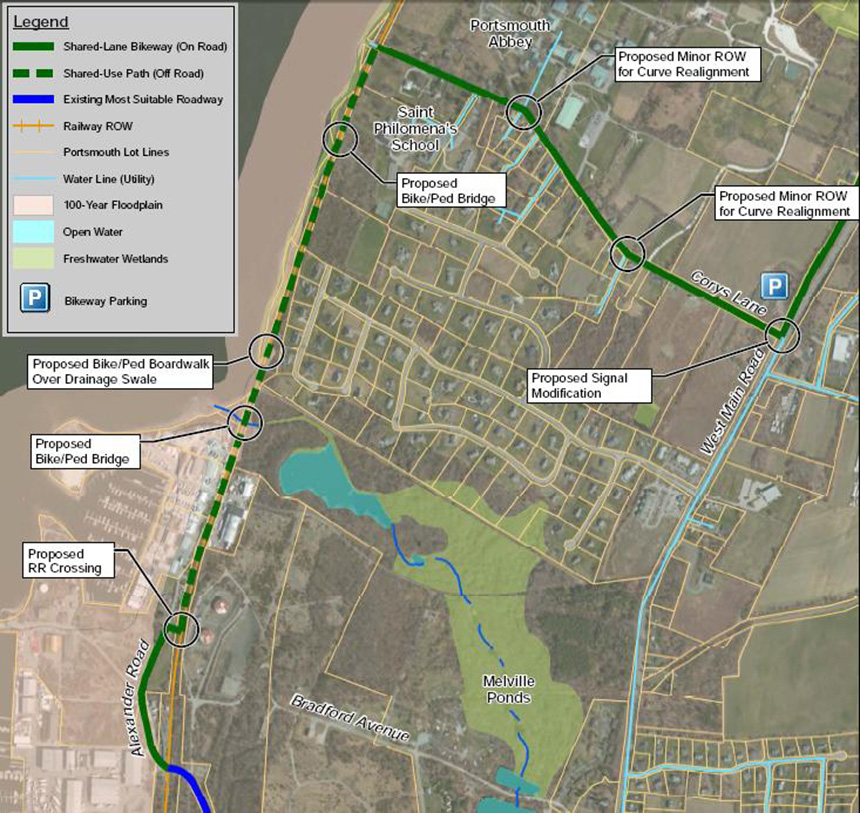
The alternatives identified in the report are the Railroad-Shoreline Alternative, the Powerline Alternative and the Melville Ponds Alternative.
Railroad-Shoreline Alternative
This option begins at the intersection of West Main Road and Old West Main Road. It travels south about 0.6 miles along Old West Main Road — marked with shared-lane arrows (sharrows) — to Cory’s Lane. Sharrows continue northwest on Cory’s Lane toward the Saint Philomena School for about 0.8 miles to the rail corridor on the island’s western shoreline.
The bikeway continues south along the east side of the railroad corridor for about a mile on a rail-with-trail-style bike path, similar to segments of the Blackstone River Bikeway. After crossing the railroad tracks, sharrows continue south on Alexander Road for about two-tenths of a mile to the segment’s terminus at Stringham Road/Burma Road.
The Railroad Shoreline Alternative would require the most new infrastructure, including new bike and pedestrian bridges, a bike and pedestrian boardwalk, a fence dividing the bike path from the railroad tracks, and a railroad crossing. The estimated cost is $3.5 million, the most costly of the proposed alternatives. This option would require a complicated permitting process, and likely raise the most objections from abutters. It requires a maintenance agreement with the Department of Transportation for a trail within an active railroad corridor, and additional insurance costs.
This option would provide views of Narragansett Bay, would require the least number of right-of-way acquisitions, and offer the most pleasant biking and walking experience compared to the other alternatives, according to the report.
Powerline Alternative
This option also begins at the intersection of West Main Road and Old West Main Road and extends south to Cory’s Lane via sharrows. From Cory’s Lane, the bikeway continues south about 0.4 miles, as an off-road shared-use path adjacent to and on the west side of West Main Road to an existing powerline corridor at the north edge of the Melville Ponds Campground.
The bikeway turns to the southwest and continues along the powerline corridor for about a tenth of a mile, then turns northwest and continues along the powerline corridor for about 0.6 miles as an off-road shared-use path until it reaches the railroad corridor. The bikeway follows the railroad corridor south for about 0.4 miles until it crosses the tracks onto Alexander Road. Sharrows continue south to the segment’s terminus at Stringham Road/Burma Road.
A new bike and pedestrian bridge and a railroad crossing would be required for this option. The estimated cost is $2.7 million. Right-of-way acquisitions along West Main Road would be required, as would coordination with National Grid for the segment along the utility corridor. Environmental permitting and railroad issues would be similar to the Railroad-Shoreline Alternative for the portion along the railroad corridor.
The Powerline Alternative provides a section of bikeway along the shoreline, access to a portion of the Melville Ponds Campground and passes through the commercial area of King’s Grant, according to the report.
Melville Ponds Alternative
This option originates at the intersection of West Main Road and Old West Main and extends south to Cory’s Lane via sharrows. It continues south as an off-road shared-use path adjacent to West Main Road to the powerline corridor. The bikeway then turns southwest and continues for about 0.36 miles as an off-road shared-use path before turning south onto Smith Road. Sharrows continue south on Smith Road, then briefly east on Bradford Avenue, and then south again on Sullivan Road to Stringham Road.
The Melville Pond route doesn’t require major infrastructure projects. The estimated cost is $1.8 million, the least expensive of the proposed alternatives. Right-of-way acquisitions along West Main Road would be required, but environmental permitting would be significantly less challenging than the other two alternatives, and railroad issues would be avoided completely.
While this option results in the least off-road bikeway miles, and none along the shoreline, it provides connections to the commercial areas of King’s Grant and access to the Melville Ponds Campground, according to the report.
Public feedback
Bill DeSantis, VHB’s corporate director of bicycle transportation planning and design, presented a brief explanation of the report’s findings to a crowd of about 40 mostly Aquidneck Island residents at a recent public hearing at Town Hall. The presentation was followed by public comments.
Most of the comments were in favor of advancing one of the alternatives to the state for inclusion in the TIP. Many who spoke didn’t offer a preferred alternative, but said that any of the proposed routes would be beneficial.
Tina Dolan, a Newport resident and former head of the Aquidneck Island Planning Commission, said communities with strong biking infrastructure have happier and healthier people. She also said bike paths help the economy and tourism.
Tom O’Neill, a Newport resident, expressed support for “whatever route would attract the most people.” O’Neill said a bike route would encourage biking, walking and family-oriented recreation that could help combat childhood obesity.
Tyson Bottenus, of Newport, said he began biking out of necessity. “It was because of the economic recession that I started riding a bike,” he said, explaining that biking was cheaper than driving a car when he couldn’t find steady employment. He said bicycling on Aquidneck Island is challenging and dangerous and encouraged the Town Council to create better biking facilities.
Tim Leary, a Portsmouth resident, said he’s lived on the island for 25 years, but doesn’t ride in Portsmouth. “It’s dangerous,” he said. Leary said he bikes in Tiverton and on the East Bay Bike Path, where, he said, it’s safer.
Liza Burkin, of Bike Newport and Women Bike RI, said she recently spoke to many Portsmouth residents who expressed the desire to bike to work, but don’t feel safe on the town’s roads.
“Biking to work is up 61 percent between 2005 and 2012 (in the United States),” she said, noting that Rhode Island only ranks in the middle of the pack in terms of the percentage of people who bike to work. “We’re one of the smallest and densest states. We need to join the party.”
Most people who expressed their preferred alternative chose the Melville Ponds Alternative. In most cases, supporters of this option criticized the other two alternatives.
Tom Greene, a Portsmouth resident, said the Melville Ponds route would be cheaper, generate more economic benefit and offer access to recreational opportunities within the Melville Pond area. The other alternatives, he said, would be more environmentally disruptive, require obtaining difficult permits, lower abutters’ property values and only include a 750-foot stretch with views of Narragansett Bay.
Bunny Miller, a Portsmouth resident and the chairwoman of the Dog Park Planning Committee, said she supports the Melville Ponds Alternative because it will bring residents directly to the future dog park in the Melville Ponds area.
Nancy and Paul Laurienzo, Portsmouth residents, both supported the Melville Pond Alternative because it offered access to the Melville Pond Campground, is easiest to build and would be more useful to Portsmouth residents on a regular basis. Nancy said Portsmouth lacks sidewalks and crosswalks and the Melville Pond Alternative could help solve that problem.
“We’ve been married 33 years and we finally agree on something, the Melville route,” Paul said.
Town Council member David Gleason spoke at the meeting and said he supported the Melville Pond Alternative. He said he was disappointed that none of the options offer a truly family-friendly bike path.
“We are going to have a bike path, no doubt, but it’s still not going to be a family-friendly one that me and my family will be on,” he said.
He also noted that none of the alternatives travel through the town’s restaurant district of Island Park and suggested studying that option.
Peter Rice, of Newport, was the only person at the hearing opposed to all of the proposed alternatives. Rice, who said he bikes 5,000 miles a year and travels through Portsmouth about four times a year, said Portsmouth already has enough roads suitable for biking.
According to Rice, Portsmouth’s most dangerous area for bikers is on Quaker Hill. He suggested extending and widening a sidewalk along Quaker Hill that bikers could ride on, instead of the road.
“Why not fix the easy problems first?” he asked. “If you are not going to fix the easy problems, why are you going to the long-term problems?”
DeSantis rebutted Rice’s claim that Portsmouth was currently a safe place for bicyclists with a video taken from his bike while he rode on Bristol Ferry Road. The video showed DeSantis riding in the right-hand lane of a two-lane road with cars speeding by him on his left. The video ends with him being cut-off by a driver.
He also noted that while riding a bicycle on a sidewalk is legal in Portsmouth, it can be dangerous for riders and pedestrians.
DeSantis did agree with concerns that a bikeway could take a long time to build, saying design and construction would take four to five years after the project received TIP funding, which could be years away.
Bari Freeman, executive director of Bike Newport, also contested Rice’s suggestion that a bike path shouldn’t be a priority for Portsmouth.
“If you look at the bicycle map for Aquidneck Island you’ll see three areas in Portsmouth that are called-out in a different color than anything else on the map, and it says, ‘caution, consider dismounting, getting up onto the grass and walking your bicycle here,’ because there is no way to ride here safely.”
Freeman also said the president of the Narragansett Bay Wheelmen has declined her requests to promote organized Aquidneck Island bike rides to his membership because, she quoted, “Portsmouth Rhode Island is a deadly place for bicyclists. There is not a way to ride through Portsmouth to Middletown without either riding on East Main Road or West Main Road. Both of these roads are not safe for cyclists. Until Portsmouth finds a safe way for cyclists to pass through their town, the Narragansett Bay Wheelmen advocates against riding through Portsmouth.”
Public comment will be accepted until June 19, at which point concerns will be compiled and responded to by VHB.
Categories
Join the Discussion
View Comments
Your support keeps our reporters on the environmental beat.
Reader support is at the core of our nonprofit news model. Together, we can keep the environment in the headlines.