Narragansett Bay Region Feels Squeeze of Solar Development
August 30, 2024
Share
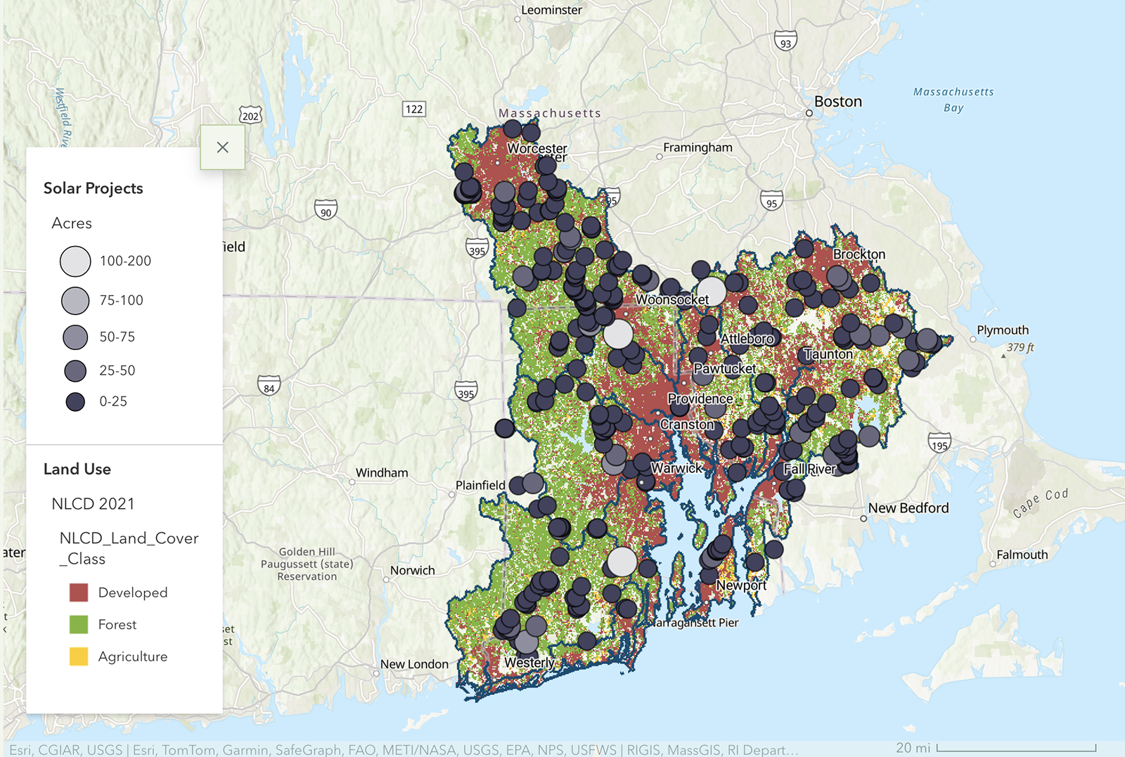
PROVIDENCE — Early last month the Narragansett Bay Estuary Program (NBEP) released “Into the Woods: Solar in the Forest” to examine the number and location of ground-mounted solar projects in the region and to assess how much green space has been lost to solar development.
Working with Clark University in Worcester, Mass., the NBEP mapped solar arrays in the forests of the 113 municipalities in Rhode Island, Massachusetts, and Connecticut that make up the Narragansett Bay region. Nearly 4,000 acres in the region, most of which was undeveloped, have been cleared for solar projects.
“By far, most solar projects were installed in forested areas or cropland,” according to the recently published study.
The story map created by the effort includes key statistics, both locally and statewide. For instance, 70 of the 113 cities and towns in the region have ground-mounted solar development, covering 3,979 acres across 350 solar fields. Of those nearly 4,000 acres, only 434 were already developed.
“We were looking at our land use, and it was changing as it always does,” Courtney Schmidt, staff scientist for the NBEP, recently told ecoRI News. “There’s more development, fewer forested lands, but it’s not, as we’re finding out, it’s not all housing.”
North Smithfield, R.I., has the most ground-mounted solar acreage, with 285 acres across 14 solar fields. Uxbridge, Mass., has the most solar fields, with 23 across 152 acres. In South Kingstown, R.I., two solar fields encompassing 27 acres sit within a coastal salt pond watershed.
The story map also breaks down ground-mounted solar development in river watersheds, including the Blackstone, Pawtuxet, and Taunton, and in the coastal watersheds of Narragansett Bay and Little Narragansett Bay.
The comprehensive project notes that fragmenting forests for solar projects and other development threatens one of the Narragansett Bay region’s most unique habitats — core forests, which are contiguous areas of forestland greater than 250 acres.
“Losing a forest is not what you want to do. And in this case [solar development], they’re clear-cutting the forest and they have to clear-cut more than what they actually need for the panels, because you need access roads and a buffer around it,” Schmidt said. “Solar is good. We need it. Diversifying energy sources is important, and there’s space to do both.”
In 2021, the region had 239,333 acres of core forest, representing about 40% of the entire forested area of the region (603,222 acres). In 2008, before solar projects were tracked, the region had 265,229 acres of core forest. In those 13 years, the region lost 25,895 acres (10%) of core forest to development, including solar installations.
The plan, according to Schmidt, is to add the three-state region’s municipal solar ordinances and bylaws to the story map.
She noted the database is expected to be updated every few years, and NBEP and Clark are working on how to map solar in developed spaces, such as carports and rooftops, “but remote sensing struggles to tell the difference between solar panels and pavement.”
Renewable energy reduces climate-changing greenhouse gases and strengthens regional and local energy independence. Rhode Island, Massachusetts, and Connecticut have a combined 6,469 megawatts of solar power, according to the Solar Energy Industries Association.
Much of that solar energy is being produced by ground-mounted solar installations, and that’s where southern New England’s forests enter the equation.
While renewable energy plays one of the most significant roles in mitigating the climate crisis, nature also offers solutions, if given the chance. Chief among the natural world’s climate-change-busting tools are trees, or more specially forests.
The average forested acre in Rhode Island stores 76 metric tons of carbon dioxide and absorbs an additional 1.3 metric tons of CO2 from the atmosphere every year, according to a 2019 report titled “The Value of Rhode Island Forests.”
Assuming those figures are the average for a forested acre throughout the Narragansett Bay region, the Clark-NBEP project determined the area’s 603,222 acres of forest store 45 million metric tons of carbon and absorb an additional 700,000 metric tons of CO2 annually — the equivalent to the annual emissions of 140,000 cars.
Mass Audubon and Harvard Forest conducted a similar study last year, determining that Massachusetts forests capture carbon from the atmosphere equivalent to about 10% of the state’s emissions — about 100 million metric tons of CO2.
While trees are critical for capturing and storing carbon, that free service and the many others forests provide, such as wildlife habitat, biodiversity support, drinking water filtration, flooding protection, and shade, are routinely ignored when it comes developing ground-mounted solar energy. This shortsighted approach has divided communities and vilified solar.
The Mass Audubon-Harvard Forest project noted that urgency to act on the climate crisis “does not justify the haphazard approach to solar deployment witnessed in the Commonwealth over the past decade.”
“The current trajectory of deployment of large ground-mount solar is coming at too high a cost to nature,” according to the organizations. “Concerns about impacts to nature are partly responsible for erosion of public support for solar, with many communities now seeking to slow or entirely stop new ground-mount solar systems.”
The best way to unite communities and stimulate increased solar development with minimal pushback is to target more already-disturbed areas for installations, such as Superfund sites, brownfields, closed landfills, highway medians, carports, and rooftops. Many of these disfigured areas cost more to develop into solar arrays, but since 2013 the price of solar panels has declined by 85%, according to the National Renewable Energy Lab.
Government can also lend better support, akin to what it did for the fossil fuel industry, such as helping to replace the nation’s network of trains and trolleys with roads and the Interstate Highway System, which has been called the “greatest public works project in history.”
Historically, subsidies granted to the fossil fuel industry were designed to lower the cost of fossil fuel production and incentivize new domestic energy sources, according to the Environmental and Energy Study Institute (EESI).
“Today, U.S. taxpayer dollars continue to fund many fossil fuel subsidies that are outdated, but remain embedded within the tax code,” according to the EESI. “The United States provides a number of tax subsidies to the fossil fuel industry as a means of encouraging domestic energy production.
The bipartisan Washington, D.C.-based nonprofit noted these taxpayer-supported perks include direct subsidies to corporations and tax benefits to the fossil fuel industry. “Conservative estimates” put U.S. direct subsidies to the fossil fuel industry at about $20 billion annually, according to the EESI.
“As we scale up our deployment of solar, we must also recognize the instrumental role that natural and working lands play in stabilizing our climate system,” according to Mass Audubon-Harvard Forest. “More than 60 percent of Massachusetts is covered by diverse forests, which are storehouses of carbon. Our trees alone contain the equivalent amount of carbon as in five years of statewide fossil fuel emissions. Forest soils contain a similar amount.”
Schmidt noted one way to better protect forestland is to implement comparable laws that govern the protection of wetlands.
“If we had the similar protections that we did for wetlands, I think we’d be having a different conversation,” she said, “because you can’t you can’t put solar in a wetland, you can’t build in a wetland. That gives us a little bit more power to protect those areas.”
Last year the Rhode Island took a small step in that direction, when the General Assembly passed and the governor signed a law to better protect core forests.

The place to put solar is in parking lots. Movie theaters, malls, super markets. and roofs. if qe did that we could stop eating forests. Plus it would cool the parking lots. clearing treees for solar ought to be illegal.
I’ve said it before, and I’ll keep on saying it. The ideal locations for solar panels are roofs, parking lot canopies, brownfields and capped landfills. The clearing of forests and covering of agricultural fields with solar farms is the very last thing we should be allowing. The state and federal governments should be doing more to incentive the use of proper sites.
this is one reason I keep pushing back against the conflation of renewable energy with so-called “clean energy” – obviously clearing forests and killing most of the creatures that lived there is not “clean” but the feel-good phrase, useful for politicians and fundraising, sends a message that people prefer to hear that we can keep consuming as much as we want as long as we heat, cool, light, drive, fly, eat meat etc with “clean energy.” There is no such thing. We should be prioritizing reducing the growth in demand for energy that keeps fossil fuels booming even as renewables come on
Didn’t Rhode Island pass a law in 2023 that protects core forests from solar development? Why is that not mentioned in this article?
Barbara, the law and a link to it are provided in the last paragraph. — Frank Carini, ecoRI News